
Maps for Hampi
T
hanks to it sprawling nature of the Hampi ruins, it is useful to carry a Hampi map when you visit Hampi ruins. For a casual visitor to Hampi, it may not be possible to ‘cover’ the whole sites in a couple of days stay. Nevertheless a map can better prepare you to chalk out your local itinerary. Plan your basic circuit and pick & choose the various sites on the move.If you are not carrying a guide book or a Hampi site map, buy one when you reach the ruins site. You can get a simple map (covering the popular) sites for about Rs20. The map sellers do approach you as you land at the Hampi bus stand or aa you start doing the sightseeing. As the shops sell maps are located around the Hampi Bazaar area, buy one from here as the far areas are devoid of any such shops.
Archaeological Survey of India has displayed may large and detailed sitemaps near many monuments in Hampi. There are about half a dozen such maps in Hampi.
A few useful maps for your convenience is listed here
India Map : This map gives you a basic idea about the location of India with respect to the neighbouring countries, Karnataka State, where Hampi is located. You can aslo see the location of Bangalore, which is the state capital of Karnataka.
A general Map of Hampi Ruins. You can get an overall idea about the width & breadth of the ruins in from this map. Some of the key landmarks in Hampi are marked here. For example the hills, the river and also the location of about 80 monuments are labeled in this map. Use this map before you see a more detailed specific area map of Hampi. Hampi Ruins Map
Hampi Ruins (map1): Map showing Hampi Bazaar , Hemakuta Hill area , Virupaksha Temple & Virupapur Gadde.
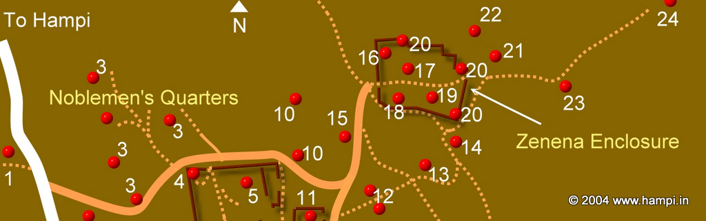
Hampi Ruins (map4): Map showing Archeological Museum, Basement of Palaces, Bhima’s Gate, Bhojanasala, Chandrashekara Temple, Dannayaka Enclosure, Domed Gateway, Elephant Stables, Fortified Walls, Ganagitti Temple, Granaries, Hazara Rama Temple, Horse Stable, Jaina Temple, Lotus Mahal, Malyavanta Hill, Octagonal Bath, Octagonal Water Pavilion, Pattabhi Rama Temple, Pattanada Yellamma Temple, Queen's Bath, Ranga Temple, Rockcut Shrine, Royal Enclosure, Saraswathi Temple, Srinagarada Hebbagilu, Tenali Rama Pavilion, Zenana Enclosure
Hampi Map 5 Map showing Ahmed Khans Mosque & Tomb, Aqueducts and Canals, Archeological Museum, Band Tower, Basement of Palaces, Bhimas Gate, Bhojanasala, Chandrashekara Temple, Dannayaka Enclosure, Domed Gateway, Elephant Stables, Fortified Walls, Ganagitti Temple, Granaries, Guards' Quarters, Hazara Rama Temple, Horse Stable, Jaina Temple, Kings Audience Hall, Large Stone Trough,Lotus Mahal, Mahanavami Dibba, Malyavanta Hill, Mint Area, Mohammadan Watch Tower, Mosque, Noblemens Quarters, Octagonal Bath, Octagonal Water Pavilion, Palace of Krishna Devaraya, Palace of Vira Harihara, Pan Supari Bazaar, Parshwanatha Temple, Pattabhi Rama Temple, Pattanada Yellamma Temple, Public Bath, Queens Bath, Ranga Temple, Rockcut Shrine, Royal Enclosure, Saraswathi Temple2, Srinagarada Hebbagilu, Stepped Tank, Stone Door, Tenali Rama Pavilion, Treasury Building, Watch Towers, Water Pavilion, Water Tank, Zenana Enclosure
Hampi Map 6 : Map showing Domed Gateway , Chinna Hundiam Temple, Malyantha Hill, Raghunatha Temple, Siva Shrine, Venkatapuram
Royal Center Map. A detailed map of the citadel area of Hampi. About 40 monuments & palatial remains are marked in this map. Royal Center Map
The map shown the location of about 20 Temples , River & the hills.
Sacred Center Map
The location of airports for Hampi. Most of them are located in Karnataka. The Hyderabad & Goa's airports too shown in the map. Airports Map for Hampi
Access map for Hampi. The relative locations of India,Karnataka State & Hampi are shown in this single map Access map for Hampi
Rail map of Karnataka. Major rail routed for Hampi is shown Rail map for Hampi
Lodging locations in Hampi. A map of Hampi with the the lodging locations marked. Hampi Hotels
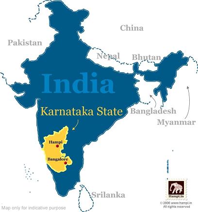
Hampi on India Map
Location of Hampi in Karnataka, India
 bicycle/mopeds. Of course you can hire a cab too. See the itinerary plan that discusses a One Day Hampi tour as well as a more realistic , 3 Days Hampi tour plan . This is a busy map with most of the appractions shown in a single map. You can also see the detailed map of Sacred Center and Royal Center. ">
Hampi Ruins Map. The attractions in Hampi are scattered around 25 Sq Km area. Each square block represents approximately 1 sq km (1km x 1km). This should give you an idea about how to plan for the exploration.
Explore hampi on foot as well as on bicycle/mopeds. Of course you can hire a cab too. See the itinerary plan that discusses a One Day Hampi tour as well as a more realistic , 3 Days Hampi tour plan . This is a busy map with most of the appractions shown in a single map. You can also see the detailed map of Sacred Center and Royal Center.
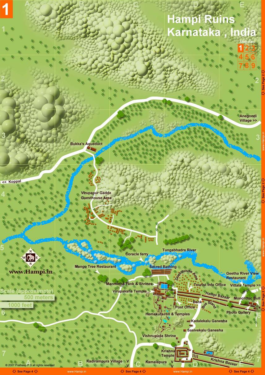
Hampi Map1
Map showing Hampi Bazaar , Hemakuta Hill area , Virupaksha Temple & Virupapur Gadde
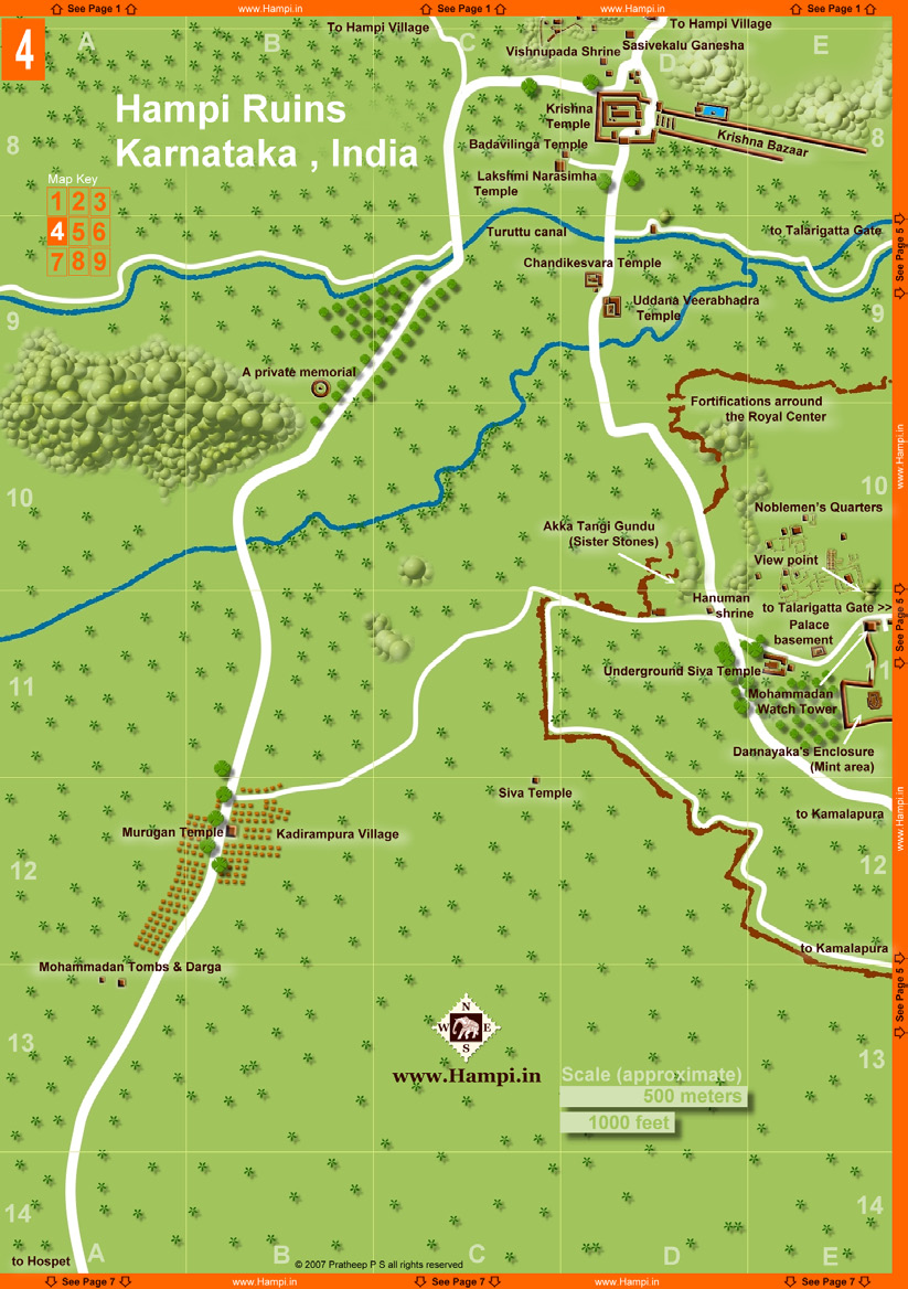
Hampi Map 4
Map showing : Archeological Museum, Basement of Palaces, Bhima’s Gate, Bhojanasala, Chandrashekara Temple, Dannayaka Enclosure, Domed Gateway, Elephant Stables, Fortified Walls, Ganagitti Temple, Granaries, Hazara Rama Temple, Horse Stable, Jaina Temple, Lotus Mahal, Malyavanta Hill, Octagonal Bath, Octagonal Water Pavilion, Pattabhi Rama Temple, Pattanada Yellamma Temple, Queen's Bath, Ranga Temple, Rockcut Shrine, Royal Enclosure, Saraswathi Temple, Srinagarada Hebbagilu, Tenali Rama Pavilion, Zenana Enclosure
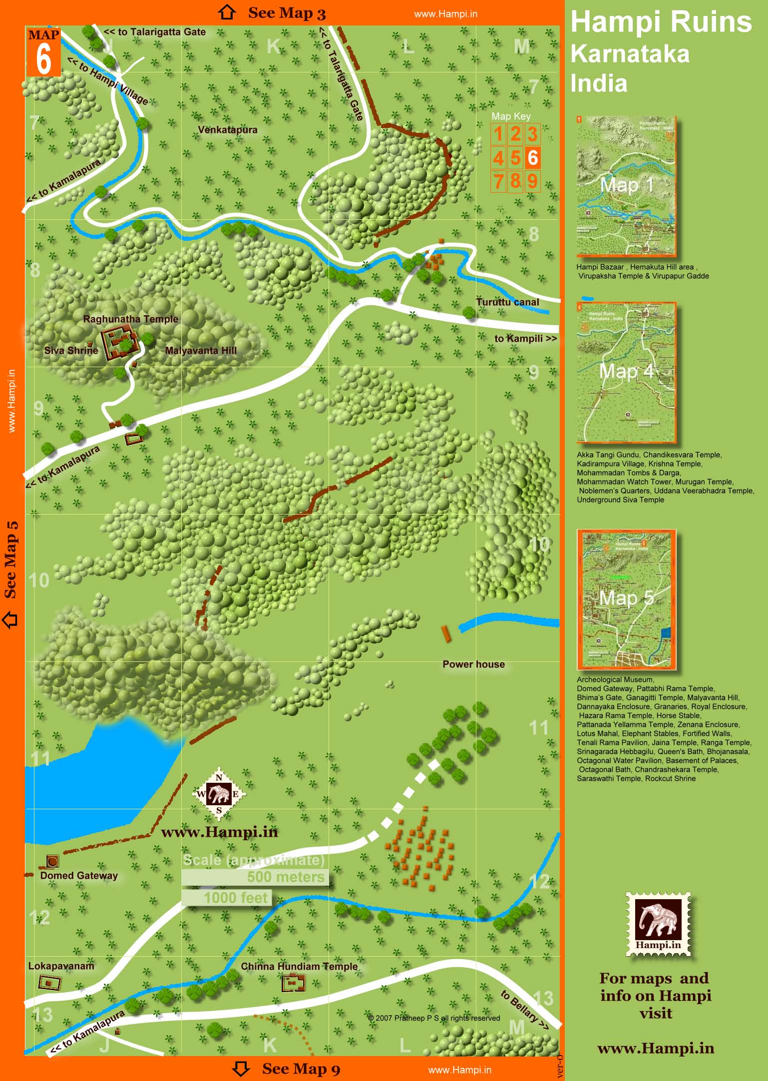
Hampi Map 6
Map showing Domed Gateway , Chinna Hundiam Temple, Malyantha Hill, Raghunatha Temple, Siva Shrine, Venkatapuram
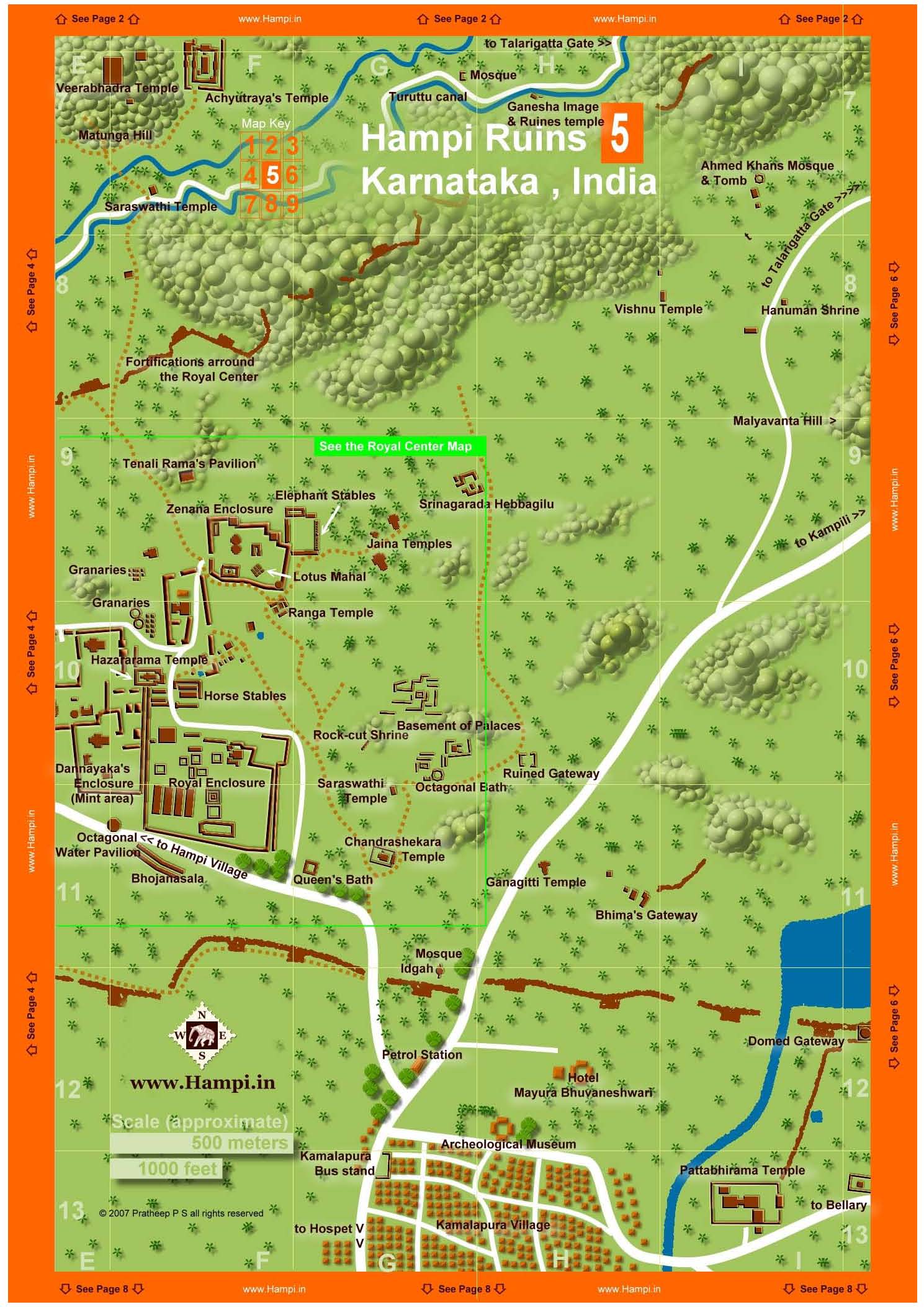
Hampi Map 5
Map showing Ahmed Khans Mosque & Tomb, Aqueducts and Canals, Archeological Museum, Band Tower, Basement of Palaces, Bhimas Gate, Bhojanasala, Chandrashekara Temple, Dannayaka Enclosure, Domed Gateway, Elephant Stables, Fortified Walls, Ganagitti Temple, Granaries, Guards' Quarters, Hazara Rama Temple, Horse Stable, Jaina Temple, Kings Audience Hall, Large Stone Trough,Lotus Mahal, Mahanavami Dibba, Malyavanta Hill, Mint Area, Mohammadan Watch Tower, Mosque, Noblemens Quarters, Octagonal Bath, Octagonal Water Pavilion, Palace of Krishna Devaraya, Palace of Vira Harihara, Pan Supari Bazaar, Parshwanatha Temple, Pattabhi Rama Temple, Pattanada Yellamma Temple, Public Bath, Queens Bath, Ranga Temple, Rockcut Shrine, Royal Enclosure, Saraswathi Temple2, Srinagarada Hebbagilu, Stepped Tank, Stone Door, Tenali Rama Pavilion, Treasury Building, Watch Towers, Water Pavilion, Water Tank, Zenana Enclosure
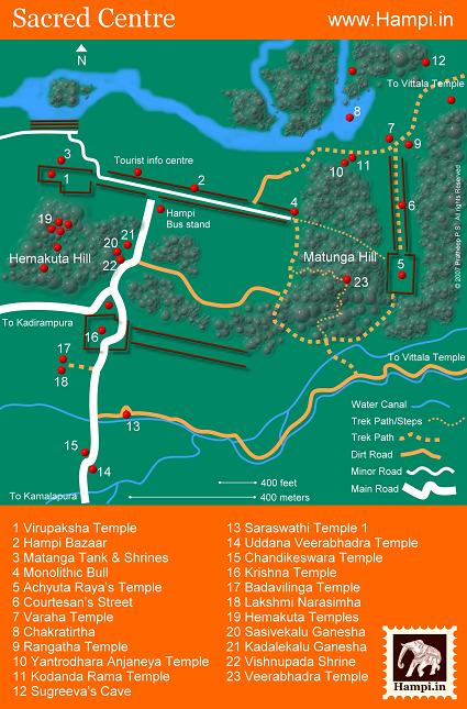
Sacred Center Map, Hampi
The Sacred Center part of Hampi. Most of the temples and other religiously significant sites are located in this locality, hence the name.
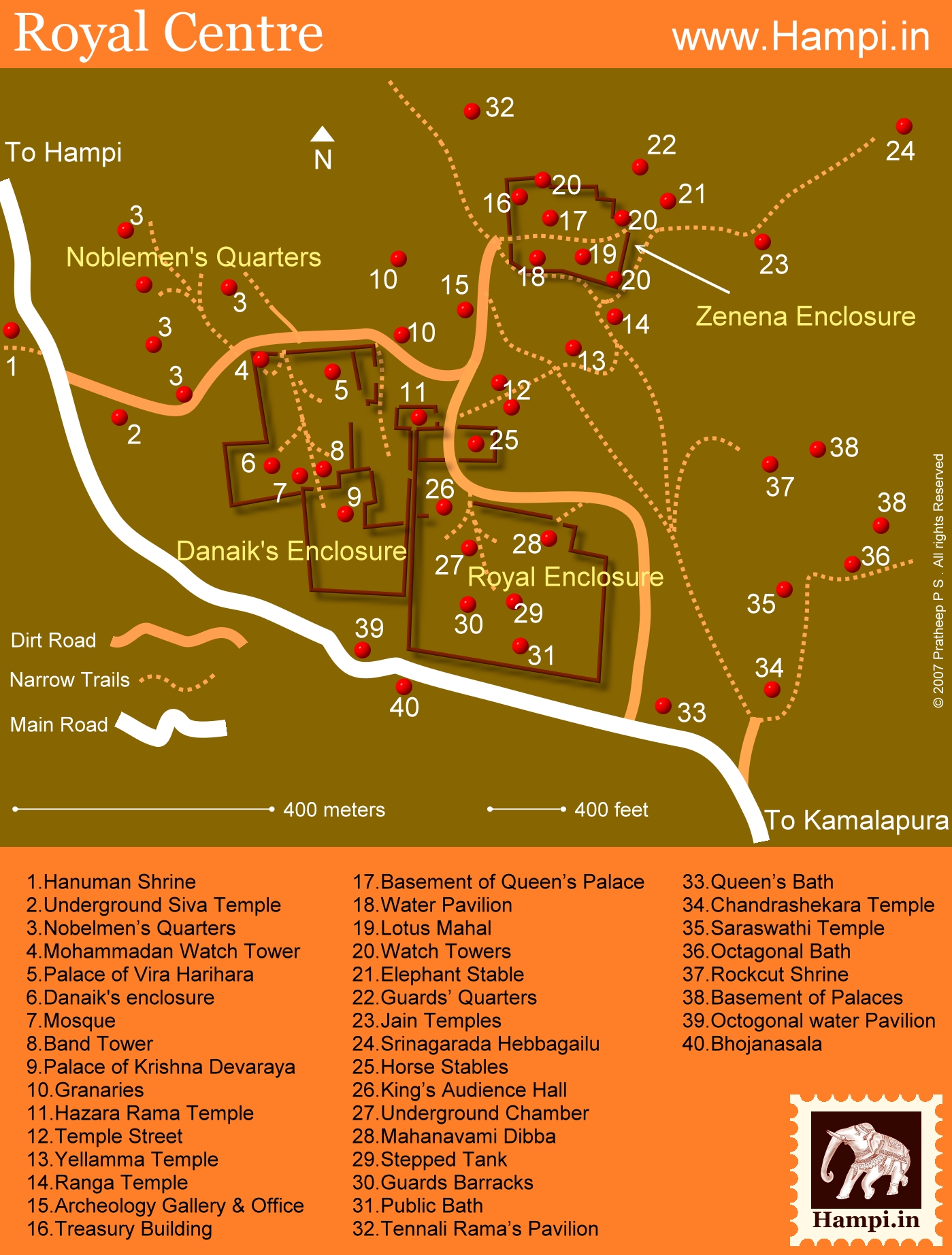
Royal Center Map
Map of Hampi showing attractions in Royal Center Map like the Royal Enclosure,Lotus Mahal, Zenena Enclosure, Hazararama Temple, Queen's Bath, Basement of Palaces etc.
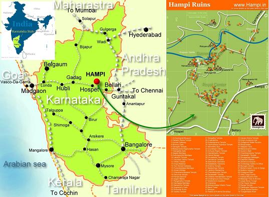
Location of Hampi on Karnataka map
Hampi is located in Karnataka State in southern India. Hospet is the nearest major town to Hampi. Mumbai to Hampi distance about 700km. Hampi is about 380km southwest of Hyderabad. Bangalore to Hampi is about 365km
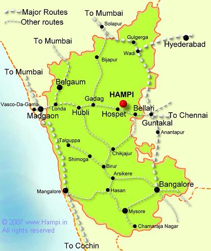
Railways Map of Karnataka
Railways map of Karnataka showing connectivity to Hampi.